News

Rogers Middle School Ditch

This project has been completed

Rogers Middle School Ditch was regraded and reseeded to improve flow and functionality.

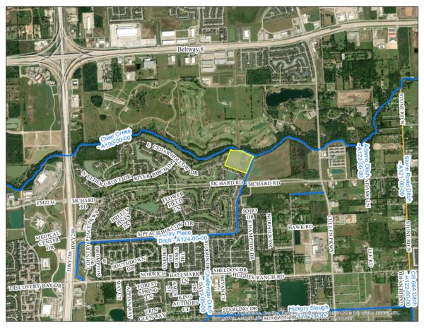
Country Place Detention Basin

This detention pond will be located on a 20.031-acre tract near Country Place ditch and Clear Creek.  This project is located in the Country Place development adjacent to both Country Place Ditch and Clear Creek.  The total area of the tract will be fully utilized for flood mitigation and will provide additional detention storage in the area.

Pre-Construction

In Progress

McHard Rd. Detention Pond

This project is part of a collaborative effort with the City of Pearland

This detention facility is designed as a regional mitigation basin strictly for the benefit of the watershed with no availability to be sold or allocated for public of private projects as part of a joint project with the City of Pearland.  This area was identified in the Master Drainage Plan and the specific property was found to be available during the design process of the McHard Rd. Extension project.  It is approximately 35 acres and the volume will be maximized to provide ultimate benefits to the surrounding community.

Phase II (In Progress)


Phase I (Completed)

Phase I - Pre-Construction

Phase I - In Progress

Completed

Harrison Rogers Detention Facility

The recently dedicated Harrison Rogers Detention Facility will deepen the currently constructed detention pond on the eastern portion of the property and connect it to the proposed detention pond on the western portion.  The ponds will utilize a pumped system to fully maximize the capacity and will provide additional flood mitigation for the surrounding neighborhoods of Mimosa Acres and Willowcrest.

The ponds are located at the BDD4 offices property on either sides of the back parking lot and shop.

West Pond

East Pond

Cowart/Bailey Pond Weir Improvement Project

This project has been completed

The District has identified the need for improvements to the weir structures at the Bailey Detention Pond (south of Bailey; west of Wells Dr.) and the Cowart Diversion Detention Pond (between Veterans Dr. and Wells Dr.).
A drainage study of the Hood Ditch area was completed in August 2017 which identified several projects that would reduce flooding along Hood Ditch. The improvements at the Diversion Pond were included in this study and was used as a guide to scope this project.
The proposed optimization of the existing weir to Bailey Pond has also been identified by observations during rain events and the LOMR for Coward Creek Diversion improvements. These improvements will provide efficient use of the available volume in both ponds and will reduce the flooding risk to residents along the north/south streets between Bailey and CR 100.

West Lea Drainage Improvements

This project is part of a collaborative effort with the City of Pearland

The West Lea Drainage Improvements project will be a multi-phased project that will incorporate improvements to the interior of the West Lea subdivision drainage system, the drainage ditch that conveys storm water from the subdivision, and Mary’s Creek which is the receiving stream.

Mary’s Creek will be reconstructed to install in-line storage through benching sections on the north bank of the channel.  The extents of the channel benching will start from the weir at the West Mary’s Detention Basin to the channel crossing at Magnolia Pkwy.  A total of approximately 3,800 linear feet of benching will be constructed with stop blocks placed at an interval of approximately 500 feet in order to keep the channel conveyance similar to the existing condition, thereby creating additional storage in the floodplain with the benched sections.

The Mary’s Creek benching project will coincide with the rehabilitation of the West Lea Ditch and drainage improvements within the West Lea subdivision.  These improvements will not alter the runoff volume from the West Lea subdivision, only the timing of inflow into Mary’s Creek,  reducing the contribution of runoff to Mary’s Creek during peak times.  The benching section on Mary’s Creek will provide additional capacity without impacting the 100-year storm frequency.

Installation of Drainage Improvements

Coronavirus (COVID-19)

Coronavirus Updates

Brazoria Drainage District No. 4 is closely monitoring all Coronavirus (COVID-19) information from public officials and will make any necessary adjustments to our daily business.  The District is following the 6′ social distancing guidelines for all in person meetings and all visitors to the District offices must wear a mask.

For more information please visit the following links:

Federal Flood Risk Reduction Project – Clear Creek

The Clear Creek Federal Flood Damage Reduction Project is a partnership project between the U.S. Army Corps of Engineers, the Harris County Flood Control District, Galveston County, and Brazoria Drainage District No. 4.  As of the June 2019 Project Partnership Agreement between the Corps and the Harris County Flood Control District, the Flood Control District is the lead agency for this project, under a non-federal implementation pilot program authorized by Section 1043(b) of the Water Resources Reform and Development Act (WRRDA) of 2014.

The portion of this project within the limits of Brazoria Drainage District No. 4 is Clear Creek between SH 288 and Dixie Farm Road and Mary’s Creek from Harkey Road to SH 35.

For more information please click on the following links:

Hazard Mitigation Plan

Hazard Mitigation Plan DRAFT – 10/17/2024


The District is in the process of updating it’s Hazard Mitigation Plan.

Hazard Mitigation Plan Update 2025

Please click on the link or scan the QR code below to participate in a survey:

HMP Survey

Brazoria Drainage District No. 4’s Board of Commissioners has adopted the updated Hazard Mitigation Plan at the January 7, 2020 board meeting.

The updated plan can be downloaded at the following link:

  BDD4 Hazard Mitigation Plan (Jan. 2020)

No Early Voting

Notice: Brazoria Drainage District No. 4 IS NOT an early voting location.

List of early voting locations:

    • Pearland East Branch Location – Tom Reid Library: 3522 Liberty Drive
    • Pearland West Branch Location – Westside Event Center: 2150 Country Place Parkway
    • Pearland Shadow Creek Location – Pearland Westside Library: 2803 Business Center Drive #101


City of Pearland – Important Voting Dates:

Click here for City of Pearland voting information
Verified by ExactMetrics